|
Index
What
is S79
Adventure?
Why Seychelles?
Location
Tourism
and Nature
Amateur
Radio Operator
Equipment
Frequencies
Beaming
head
QSL
and Logs
Indíce
O
que é a Aventura S79?
Porquê
Seychelles?
Localização
Turismo
e Natureza
Operador
Equipamento
Frequências
Direcção
da Antena
Cartão
QSL e Diário
Click Here for the
Hottest Specials!!
Click Here for
Logs-on-line!!
|
 |
|
|
|
LOCATION
|
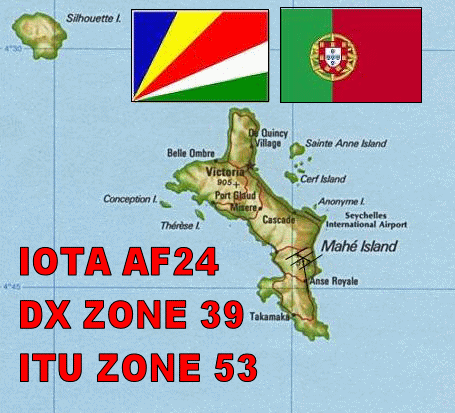
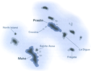
Seychelles, an archipelago in the
Indian Ocean, consists of an estimated 115 islands, most of which
are not permanently inhabited.
The second-smallest country in
Africa, Seychelles has an area of 455 sq km (176 sq mi), of which
Mahé, the principal island, comprises 144 sq km (56 sq mi).
Comparatively, the area occupied by Seychelles is slightly more than
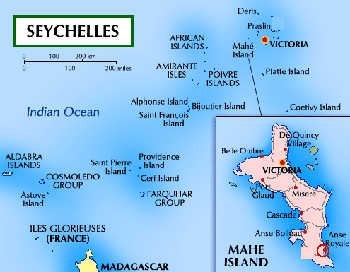
2.5 times the size of Washington, D.C. There are two main clusters:
one is a granitic group, centering around Mahé; the other, to the
SW, includes the coralline Aldabra Islands and the Farquhar group.
Situated about 1,600 km (1,000 mi) off the east coast of Africa, Mahé
extends 27 km (17 mi) NS and 11 km (7 mi) EW.
The capital city of Seychelles,
Victoria, is located on the island of Mahé
|
|
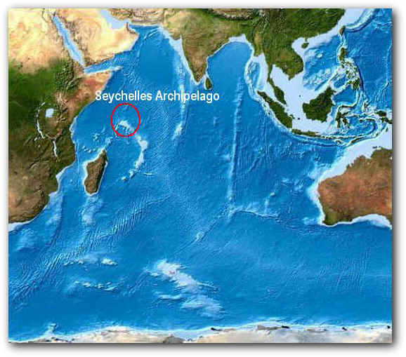
Located in
Indian Ocean East Coast of Africa. |
|
A 1600 Kms da
Costa Oriental de África sem pleno Oceano Índico situa-se o
arquipélago das Seychelles. Formado por cerca de 115 ilhas todas
diferentes de umas e outras têem em comum a Natureza .
Diferentemente de outras ilhas oceânicas, as Seychelles não são
de origem vulcânica, mas parecem ser os picos de um enorme planalto
submerso que se destacou da Índia há 65 milhões de anos. As três
ilhas centrais - Mahé, Praslin e La Digue - são de formação
granítica, enquanto as circunstantes são atóis coralinos. As
Seychelles estão entre as ilhas mais fascinantes do mundo graças
às suas praias brancas, dignas de cartão-postal, à beleza do
fundo do mar e também às paisagens internas enriquecidas pela
flora exótica e por montanhas maravilhosas. Por estar muito
afastado do continente e ser de colonização recente, o arquipélago
abriga espécies de pássaros que não se encontram em nenhum outro
lugar do mundo, e por isso algumas ilhas são verdadeiros santuários
ornitológicos. As estações são marcadas pelos ventos alísios
que sopram de sudeste, de maio a outubro, influenciando
positivamente o clima; a temperatura nunca é inferior a 24°C. As
Seychelles ficaram desabitadas até 1609, quando um navio inglês da
Companhia das Índias Orientais aproou numa das ilhas. Nos anos que
se seguiram, o arquipélago tornou-se uma base de piratas que se
transferiram do Caribe para o Oceano Índico. Em 1742, o governador
da Ilha Maurício, Mahé de la Bourdonnais, mandou um navio
de reconhecimento. O capitão, chamado Picault, deu à ilha o nome
de Mahé, em homenagem ao governador, abrindo assim o caminho para a
colonização francesa. Em 1770, a França enviou um navio de
colonos e de escravos que deram início à cultivação de
especiarias, mandioca, cana-de-açúcar, café, batata-doce, milho.
Em 1814, após a derrota de Napoleão,
os ingleses tomaram posse das ilhas.
Em 1976, o arquipélago obteve a
independência e logo se tornou uma das metas turísticas tropicais
mais exclusivas; porém, ao mesmo tempo teve início um longo período
de instabilidade política que se prorrogou até os anos 90. Durante
esses anos, consolidou-se um tímido processo de democratização
que ainda hoje continua. Nas Seychelles não existe uma população
autóctone e, por isso, são fortes as influências da cultura
africana, malgaxe, indiana e europeia, geralmente definida como
"Cultura Crioula". Os idiomas oficiais são o inglês e o
francês, falados pela maioria da população; todavia, o idioma
mais usado é o crioulo francês, também chamado "kreol
Seselwa", que foi declarado semi-oficial em 1981 e difunde-se
sempre mais na imprensa e na literatura. A maior parte da população
é católica e quase todos são praticantes fervorosos, mas muitos
ainda acreditam nos "Gris", os antigos espíritos mágicos,
e recorrem aos 'Bons-hommes" e às "Bonnes-femmes du
bois", ou seja, feiticeiros que fazem sortilégios e preparam
poções, sem levar em conta o fato que em 1958 foi banida
oficialmente a feitiçaria.
As Seychelles estão entre as melhores
ilhas do Oceano Índico onde saborear a cozinha crioula. Os
ingredientes básicos são o peixe e o arroz; a fruta, a verdura, as
ervas e as especiarias são usadas de modo extremamente criativo. Mahé
é a maior ilha entre as de formação granítica; tem 27 quilômetros
de comprimento, 8 de largura e acolhe aproximadamente noventa por
cento da população do arquipélago. É coberta por uma vegetação
tropical densa e luxuriante, onde crescem coqueiros, bananeiras,
mangueiras e árvores do pão. São muitas as praias que são
caracterizadas por uma areia branca incontaminada e por rochas de
granito, principalmente na região sul; a parte interna é
extremamente sugestiva graças às montanhas, sendo o "Morne
Seychellois" o pico mais alto, com cerca de 903 metros de
altitude. Situada na ilha de Mahé, Victoria, ou Port
Victoria, é uma das menores capitais do mundo, e também o único
porto das Seychelles caracterizado pelo tráfico constante de
ferries-boat, barcos, iates e navios de cruzeiro de todas as partes
do mundo.
Victoria é a única cidade do arquipélago
propriamente dita, pois os outros centros habitados são apenas
vilarejos. Na capital, típica cidade crioula com uma mistura de raças
e culturas, tem lugar um mercado muito original que propõe uma
grande variedade de peixes, legumes e especiarias, bastante usadas
na cozinha local.
Victoria é, no seu conjunto, uma
cidade jovem, cujas ruas, que iniciam no centro, foram reconstruídas
nos últimos vinte anos, dando à cidade um aspecto moderno e limpo.
O Palácio da Justiça e o Correio Central remontam ao período
colonial e, juntamente com algumas casas antigas e algumas lojas, são
os únicos testemunhos arquitetônicos do passado. No centro
encontra-se o "Museu de História Natural" com alguns
exemplos da grandíssima variedade da interessante fauna da ilha,
com os restos de um navio de 1570 e diversos artefatos. O "Museu
Nacional de História" repercorre os acontecimentos do arquipélago,
desde o descobrimento até os dias atuais. No Jardim Botânico,
podem-se admirar diferentes árvores originárias das ilhas e
importadas, um recinto de tartarugas gigantes e um precioso jardim
de orquídeas.
Situado na costa
sul da ilha de Mahé encontram-se o Parque Natural de Anse Forbans
aonde se vislumbram praias lindíssimas a sul encontra-se o
FAROLIM de Police Point (Nova Referência para o ARLHS SEY ????
)
|
Located in
Indian Ocean East Coast of Africa.
Ver mapa maior
|
The
Republic of Seychelles comprises 115 islands occupying
a land area of 455 km² and an Exclusive Economic Zone
of 1.4 million km² in the western Indian Ocean. It
represents an archipelago of legendary beauty that
extends from between 4 and 10 degrees south of the
equator and which lies between 480km and 1,600km from
the east coast of Africa. Of these 115 islands,
41 constitute the oldest mid-oceanic granite islands
on earth while a further 74 form the low-lying coral
atolls and reef islands of the Outer Islands.
If you are
thinking on traveling to SEYCHELLES, you will have to
take in consideration some points like SEYCHELLES's
currency, SEYCHELLES's weather, SEYCHELLES's national
holiday and SEYCHELLES's transports.
The first thing you need to know for your travels
abroad is country's currency. SEYCHELLES`s currency is
called rupee ( SR), which is divided in 100 cents.
SEYCHELLES's weather is characterized to be tropical
marine; humid; cooler season during southeast monsoon
(late May to September); warmer season during
northwest monsoon (March to May). So be sure of
choosing the proper date to travel to SEYCHELLES
|
|
|
|
O atol
de Aldabra, no sul do arquipélago
das Seychelles
a 1150 km a sudoeste de Mahé,
no Oceano
Índico ocidental (9º 25' S, 46º 25' E), pode ser considerado
uma das poucas maravilhas naturais do mundo em bom estado de
conservação e foi inscrito pela UNESCO
em 1982
na lista dos locais que são Património
Mundial.
Ele foi declarado reserva integral a 17 de Fevereiro de 1976,
poucos meses antes da independência deste país. É o maior atol do
mundo, formado por quatro ilhas em anel, com 34 km de comprimento,
uma largura máxima de 14.5 km, fechando uma lagoa com uma área de
155 km², cuja água é mudada pelas marés
duas vezes por dia, propiciando uma grande diversidade de vida
marinha.
|
|
|
| The
Seychelles, the name alone conjures up images of hidden
treasure and tropical paradise. The myths still exist; are
they just the jewel-like scattered remnants of a forgotten
continent, or simply the original Garden
of Eden,
and what arcane mysteries are locked inside of those 650
million year old rocks. Whatever, one thing is certain, you
will never find such a unique paradise anywhere else on Earth. |
|
|
SEYCHELLES
has an area of 455Km ,with a coastline of 491, this
small area is composed by 455 sq km of land and 0 sq
km of water. Seychellois geography is known by it's
Mahe Group that is granitic, narrow coastal strip,
rocky, hilly and others are coral, flat, elevated
reefs . This makes Seychellois's land specially
proclive to lies outside the cyclone belt, so severe
storms are rare; short droughts possible
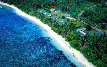
Our
QTH Location is on the South at Anse Forbans
|
|
|
|
|
|
|
 The
historical bay of Anse Forbans still fosters local myths of
treasures buried in the mountain side by the legendary pirate,
La Buse. The
historical bay of Anse Forbans still fosters local myths of
treasures buried in the mountain side by the legendary pirate,
La Buse.
Anse Forbans is a half kilometre long and a narrow stretch of
soft sand beach with coral stones scattered across it due to
the closeness of the reef, which encircles the bay
approximately 100 metres offshore. The beach is
considered safe for swimming, except for the southern part
past the chalets, where the beach leads onto Anse Marie
Louise. Anse Forbans is accessible to the public like all
Seychelles beaches.
For a romantic village name it is hard to beat Anse Forbans
Pirates Bay. It may seem fanciful but in this case there
may be some historical substance behind the name. It is
interesting that this was known as Pirates Bay from quite
early on in Seychelles history and it is perfectly possible
that buccaneers visiting these islands in the first half of
the 18th century did have some sort of a base here.
The grand-sounding Anse Royale (Royal Bay) was the location of
the Royal Spice Garden established under the auspices of the
King of France in 1771.
Being on a sandy spit almost completely surrounded by
seawater means this location has an excellent low-angle
takeoff in all directions and very low local noise levels
(other than some tropical QRN and the odd unsupressed outboard
motor!),so I am confident of working the world just so
long as the bands stay open.The village is no more than
1 mts Sea Level .lowest point: Indian Ocean 0 m
highest point: Morne Seychellois 905 m.
This is the correct place for Bird enthusiasts are already
aware of the special species seen on Seychelles Island.
Seabirds nest in the island's forested habitats, an oasis of
green surrounded by the big blue ocean. The graceful flight of
angle-winged frigate birds and the darting movement of boobies
skimming the surface of the sea water is on constant
exhibition. During courtship, male frigatebirds puff out a
handsome red throat sac, only seen during mating, to attract
partners. And the elegant white and black Abbott's Booby is a
rare sight to behold since it is only known to nest on
Christmas Island. Brown Boobies and Brown Noddies nest on the
ground near sea cliffs, where it's easy to see them up close
with their young. A notable feature of Christmas Island bird
life is their lack of shyness. Due possibly to limited
encounters with humans and predators, approaching these wild
birds up close is surprisingly easy to do and offers great
photographic opportunities.
|
|

|
|
|
Write your introductory text
here. Write your introductory text here. Write your introductory
text here. Write your introductory text here. Write your
introductory text here. Write your introductory text here. Write
your introductory text here. Write your introductory text here.
Write your introductory text here. Write your introductory text
here.
|
|
|
|
|
|
 |
|
|

